 <<back || index || next>>
|
|||||||||||||||||||||||||||||||||||||||||||||||||||||||||||||||||||||||||||||||||||||
| Chapter Contents | |
| 1.1 | |
|
1.1 |
|
|
1.1 |
|
|
1.1 |
|
|
Planned Capacity |
|
|
1.1 |
|
| 1.2 | |
| 1.2 | |
| 1.2 | |
| 1.2 | |
| 1.4 | |
| 1.5 |
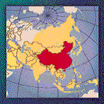
China (Eastern China)
GEOGRAPHY
- Eastern Asia, bordering the East China Sea, Korea Bay, Yellow Sea, and South China Sea, between North Korea and Vietnam
- Geographic Coordinates : 35 00 N, 105 00 E
- Area: total: 9,596,960 sq. km (land: 9,326,410 sq. km; water: 270,550 sq. km)
(CIA: The World Factbook 2001, http://www.cia.gov/cia/publications/factbook/index.html)
GEODYNAMICS
- Within the continent of Eurasia
ELECTRICITY
- Electric Generation Capacity (1/1/00E): 294 GW
- Electricity Generation (1999E): 1,308 billion kilowatthours
- Thermal:81.8%, Hydro:16.8%, Nuclear: 1.2%
(EIA: http://www.eia.doe.gov/emeu/cabs/china.html)
GEOTHERMAL ELECTRICITY GENERATION
- 255 high temperature geothermal systems identified
- Development growing 12% per year over the last 10 years
- Most resources seen in the central, southwestern China, and Tibet
- Less development in eastern China
|
Installed geothermal generating capacity (2000) in MW |
|
|
Yangbajing (Tibet) |
25 |
|
Dengwu (0.086*+0.386+0.300*) |
0.772 |
|
Huitang |
0.300 |
|
Langjiu |
2.0 |
|
Quingshui* |
3.0 |
|
Tuchang* |
0.3 |
|
Nagqu |
1.3 |
|
Total (exclude non-operation capacity) |
28.986 |
*Currently not operating.
(IGA: http://iga.igg.cnr.it/china.php)
GEOTHERMAL POTENTIAL
- Over 2700 thermal springs
- Most potential exists in the central, southwestern, and Tibet regions
- Estimates (1995) – South Tibet: 1000 MWe, West Yunnan: 570 MWe, Western Sichunan:170
- The latest estimates: 5800 MWe for 30years (Not broken down by region)
CONSIDERATIONS
WORLD HERITAGE
- Huanglong Scenic and Historic Interest Area
- Jiuzhaigou Valley Scenic and Historic Interest Area
- Wulingyuan Scenic and Historic Interest Area
(UNESCO: http://whc.unesco.org/sites/natural.htm)
NATIONAL PARKS AND RESERVES
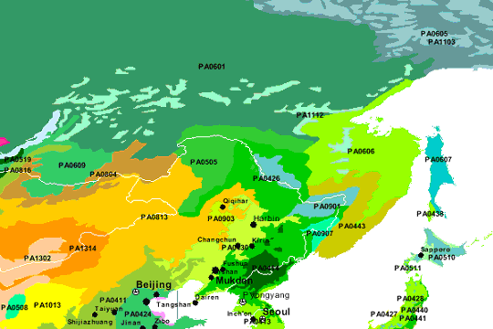
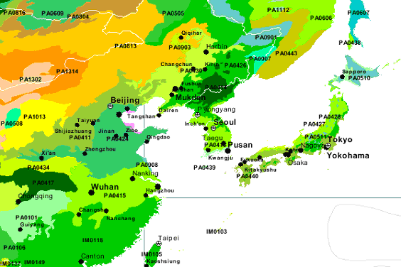
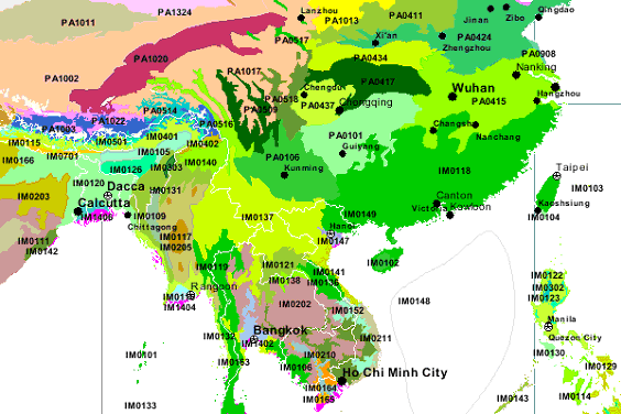
VULNERABLE / ENDANGERED ECOREGIONS
- Central China loess plateau mixed forests (PA0411)
- Changjiang Plain evergreen forests (PA0415)
- Huang He Plain mixed forests (PA0424)
- Northeast China Plain deciduous forests (PA0430)
- Mongolian-Manchurian grassland (PA0813)
- Bohai Sea saline meadow (PA0902)
- Nenjiang River grassland (PA0903)
- Yellow Sea saline meadow (PA0908)
- Jian Nan subtropical evergreen forests (IM0118)
- South China-Vietnam subtropical evergreen forests (IM0149)
(WWF: http://www.worldwildlife.org/wildworld/profiles/terrestrial_pa.html)
GEOGRAPHIC LOCATION OF ECOREGIONS
POPULATION DISTRIBUTION
|
Selected Chinese provinces |
||
|
Total |
Population |
|
|
Shandong |
86.2 |
562 |
|
Guangdong / Hainan |
72.6 |
343 |
|
Jiangsu |
68.0 |
663 |
|
Hunan |
62.5 |
306 |
|
Anhui |
58.7 |
420 |
|
Hubei |
55.9 |
301 |
|
Liaoning |
39.8 |
273 |
|
Shanxi |
29.6 |
189 |
|
Inner Mongolia |
22.0 |
19 |
|
Tianjin |
8.9 |
787 |
|
Ningxia |
4.9 |
95 |
(IIASA: http://www.iiasa.ac.at/Research/LUC/ChinaFood/data/pop/pop_3.htm)
References
- Central Intelligence Agency (CIA). (January 2002).
The world factbook 2002 – China. Retrieved from
world wide web: http://www.cia.gov/cia/publications/factbook/index.html
(September 10, 2002)
- Energy Information
Administration (EIA). (June 2002). Country analysis
briefs – China. Retrieved from world wide web: http://www.eia.doe.gov/emeu/cabs/china.html
(October
2, 2002)
- International Institute for Applied Systems Analysis
(IIASA). Data-population growth. Retrieved from
world wide web: http://www.iiasa.ac.at/Research/LUC/ChinaFood/data/pop/pop_3.htm
(October 13,2002)
- International Geothermal Association (IGA). (May
9, 2002). Welcome to our page with data for China.
Retrieved from world wide web: http://iga.igg.cnr.it/china.php
(October 2, 2002)
- National Geographic. Wild world – Terrestrial
ecoregions of the world. Retrieved from world wide
web: http://www.nationalgeographic.com/wildworld/terrestrial.html?id=1&mapServiceName=WW_Terrecos
&locWidth=120&locHeight=72&cMinx=141.8004&cMiny=45.914108&cMaxx=142.666901
&cMaxy=47.798401&size=small&detail=detailed?id=1&size=small&detail=detailed&cMinx=142.23&cMiny=41
&cMaxx=185.43&cMaxy=69.13 (October 20, 2002)
- United Nation Educational, Scientific, and Cultural
Organization (UNESCO). (July 1, 2002). National
properties on the world heritage list. Retrieved
from world wide web: http://whc.unesco.org/sites/natural.htm
(October24, 2002)
- World Wildlife Fund (WWF). Ecoregions. Retrieved from world wide web: http://www.worldwildlife.org/wildworld/profiles/terrestrial_pa.html (October 24, 2002)