|

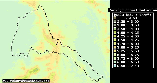
Library >>
Renewable Energy Resource
Maps >> Africa
>> Solar >>
Eritrea
Solar Energy in Eritrea
Average Annual Radiation

Solar radiation maps are an important piece of information
for Eritrean development planning for several reasons.
First, solar Photovoltaic (PV) electricity systems
with over 200 kilowatts of installed capacity are
a major supplier of high-value energy in isolated
rural villages in Eritrea.
http://www.punchdown.org/rvb/radiation/mapindex.html
(also maps for seasonal/ monthly radiation averages)
Countries
Algeria | Angola
| Burkina Faso | Benin | Botswana | Burundi | Cameroon
| Cape Verde | Central African Republic | Chad | Comoros
| Congo | Côte d'Ivoire | Djibouti | Equatorial Guinea
| Eritrea | Ethiopia
| Gabon | Gambia | Ghana
| Guinea | Guines-Bissau | Kenya
| Lesotho |
Liberia | Lybia | Madagascar | Malawi | Mali | Mauritania
| Mauritius | Morocco | Mozambique | Namibia | Niger
| Nigeria | Rwanda
| São Tomé and Príncipe | Senegal | Seychelles | Sierra
Leone | Somalia | South
Africa | Sudan | Swaziland
| Tanzania | Togo | Tunisia | Uganda | Zambia
| Zimbabwe
Related GENI Resources
Links
Solar Energy for Africa (SEFA)
AFREC
(African Energy Commission)
|
Email
this page to a friend
Updated: 2007/06/28
If you speak another language fluently and you liked this page, make
a contribution by translating
it! For additional translations check out FreeTranslation.com
(Voor vertaling van Engels tot Nederlands)
(For oversettelse fra Engelsk til Norsk)
(Для дополнительных
переводов проверяют
FreeTranslation.com )