| 
Library
>> Renewable Energy Resource Maps >>
Europe >> Wind Wind Energy Potential
in EUROPE
Map of mean 80-m wind speeds for year 2000
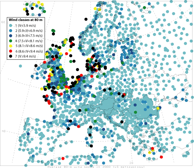
Wind speeds are calculated at 80 m, the hub height of modern, 77-m diameter,
1500 kW turbines. Since relatively few observations are available at 80 m, the
Least Square extrapolation technique is utilized and revised here to obtain estimates
of wind speeds at 80 m given observed wind speeds at 10 m (widely available) and
a network of sounding stations. Tower data from the Kennedy Space Center
(Florida) were used to validate the results. Globally, ~13% of all reporting stations
experience annual mean wind speeds ≥ 6.9 m/s at 80 m (i.e., wind power class
3 or greater) and can therefore be considered suitable for low-cost wind power
generation. This estimate is believed to be conservative. Areas with great
potential are found in Northern Europe along the North Sea. http://www.stanford.edu/group/efmh/winds/global_winds.html
Availability of standardized
evaluations of the wind energy potential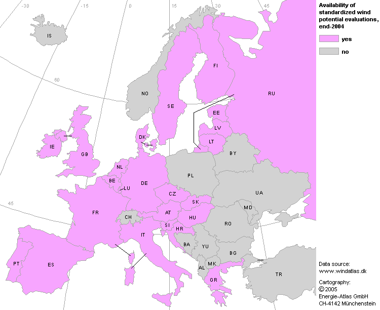
Wind energy potential can not easily be shown in simple overwiew maps. The
map indicates the countries for which wind energy evaluations are available. These
have been carried out by means of a standardized method developped by the danish
Risř Laboratory. http://www.energie-atlas.ch/wi-100.htm
Wind Map of Western Europe 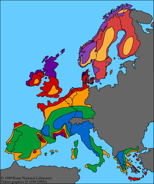
This wind map of Western Europe was originally published as
part of the European Wind Atlas. Please note that the data for Norway, Sweden
and Finland are from a later study, and are calculated for 45 m height above ground
level, and assume an open plain. The purple zones are
the areas with the strongest winds while the blue zones have the weakest winds.
The dividing lines between the different zones are not as sharp as they appear
on the map. In reality, the areas tend to blend smoothly into one another. You
should note, however, that the colours on the map assume that the globe is round
without obstacles to the wind, speed up effects , or varying roughness of the
terrain. You may therefore easily find good, windy sites for wind turbines on
hills and ridges in, say the yellow or green areas of the map, while you have
little wind in sheltered terrain in the purple areas. http://www.windpower.org/en/tour/wres/euromap.htm
CountriesAlbania | Andorra | Austria | Belarus
| Belgium | Bosnia Herzigowina | Bulgaria |
Croatia | Cyprus | Czech Republic | Denmark
| Estonia | Finland |
France | Germany | Greece
| Hungary | Iceland | Ireland | Italy
| Latvia | Liechtenstein | Lithuania
| Luxembourg | FYR of Macedonia | Malta | FS of Moldova
| Monaco | Netherlands | Norway | Poland | Portugal | Romania | Russia
| San Marino | Serbia & Montenegro | Slovakia
| Slovenia | Spain | Sweden | Switzerland
| Ukraine | United Kingdom | Yugoslavia
Related GENI Resources Links
EWEA (European Wind Energy
Association)
OWE
(Offshore Windenergy Europe)
Sahara
Wind |