
Earth Institute Researchers Present
Their Work at the American Geophysical Union Fall
Meeting
Dec 2, 2005 Earth Institute News
Wide array of topics includes climate change,
social consequences of natural disasters
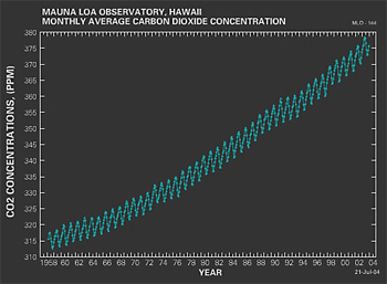
The Keeling Curve has been hailed
as the most rigorous and fundamental measure of
global change. James E. Hansen, director of the
Goddard Institute for Space Studies (GISS), will
give a presentation at AGU on how well humanity
has responded to the warning inherent in the work
of Charles D. Keeling, who passed away earlier this
year. Watch
animated Kelling Curve
Scientists from The Earth Institute
will arrive in San Francisco this week to attend the
fall meeting of the American Geophysical Union (AGU),
an annual gathering of more than 11,000 researchers
from around the world who study the Earth and other
planets. Representatives from the Lamont-Doherty Earth
Observatory (LDEO), the Goddard Institute of Space
Studies (GISS), the International Research Institute
for Climate and Society (IRI) and many other affiliates
of The Earth Institute will present a wide range of
geologic, geochemical and interdisciplinary research,
including the following:
The Katrina Disaster: A
Poor World Tragedy in a Rich Country
John Mutter, Deputy Director of The Earth Institute
at Columbia University and his colleagues examined
patterns of mortality along the Gulf Coast in the
wake of Hurricane Katrina and found surprising similarities
between that tragedy and the much larger catastrophe
that occurred in poorer countries around the Indian
Ocean one year ago. Poor populations within developing
countries have long been recognized to be more vulnerable
to natural disasters, but the same pattern has not
been as apparent in the U.S. until Katrina.
Is there Still Time to
Avoid 'Dangerous Anthropogenic Interference' with
Global Climate?
James E. Hansen, director of the GISS, examines how
well humanity has responded to the warning inherent
in the work of Charles D. Keeling, who passed away
earlier this year. The now-famous Keeling Curve, which
reveals both seasonal variability of CO2 in the Earth's
atmosphere as well as the growing effect human activity
is having on atmospheric composition, has been hailed
as the most rigorous and fundamental measure of global
change. Hansen's presentation will include the most
current measures of the agents of global change and
of climate change, including steps that have been
taken to minimize and assess measurement bias. Ultimately,
the metrics are beginning to paint an increasingly
clear picture of humanity's prospects for avoiding
dangerous anthropogenic interference with the Earth's
climate.
Global Natural Disaster
Risk Hotspots: Transition to a Regional Approach
Art Lerner-Lam, director of the Center for Hazards
and Risk Research at the Earth Institute, and his
colleagues published Natural Disaster Hotspots: A
Global Risk Analysis in 2005, which looked at the
global distribution and occurrence of multiple natural
hazards and the associated exposures of populations
and their economic output. Lerner-Lam will present
a summary of the findings of that report as well as
suggested approaches for making the transition from
a global analysis to more detailed regional and national
studies. Several regional case studies will also be
presented.
From Interoperability to
Integration: Making Data and Information Accessible
and Usable for Decision Making
Recent natural disasters in both the developed and
developing world have illustrated the many barriers
that still exist in accessing environmental and socioeconomic
data and in integrating such data to support decision
making. Bob Chen of the Center for International Earth
Science Information Networks (CIESIN) will report
on recent efforts to improve data access across the
so-called "digital divide," to establish an "information
commons" for science, and to improve the extent and
quality of integrated databases to support decision
making related to disaster management and environmental
sustainability.
Global Mortality Risk Atlas:
A Comparison of Two Global Disaster Risk Benchmarking
Projects
Silvia Mosquera Machado from IRI will present an overview
of two global natural disaster risk benchmarking initiatives:
the Disaster Risk Index developed by UNEP/GRID and
the Natural Disaster Hotspots report produced by researchers
at The Earth Institute and the World Bank. Her comparison
converts the two mortality risk indices using geographical
information systems (GIS) in such a way as to permit
global, inter-country and inter-regional comparisons
of risk.
Constraining the Rupture
Length, Duration and Speed of the Great Sumatra-Andaman
Earthquake Using Hydroacoustic Data
Maya Tolstoy of LDEO examined recordings of the underwater
noise generated by the December 26 earthquake in the
Indian Ocean made by a network of hydrophones (underwater
microphones) used to listen for the sound of nuclear
weapons tests. Using the recordings, she and colleague
Del Bohnenstiehl were able to accurately and quickly
estimate the speed and length of the rupture and to
identify two distinct phases within the entire event.
Relocation and Assessment
of the December 2004 Sumatra-Andaman Great Earthquake
Sequence and Background Seismicity
Hannah Abend of LDEO and her colleagues reevaluated
the location and depth of 3,200 earthquakes that occurred
in the region of the December 26 Sumatra-Andaman Earthquake
between January 1964 and May 2005. Their results show
that the boundary between the Andaman microplate and
the Burma subplate, which had been previously defined
as a straight line, appears to be a step-like feature
in the Earth's crust, indicative of back-arc spreading
in this region. In addition, they were able to determine
that the subduction zone downgoing slab thickness
ranges from about 25 to 35 km along the trench.
Post-Tsunami Reconstruction
in Sri Lanka: Houses or Housing?
Bijan Khazai of The Earth Institute and his co-authors
look at efforts in Sri Lanka to reconcile the need
for immediate shelter for victims of the December
2004 tsunami with the long-term perspective of rehabilitating
livelihoods for coastal residents. Currently the national-level
emphasis has been on providing housing divorced from
questions of social and economic life, whereas at
the district level, government agencies and NGOs have
placed greater importance on creating social, human
and financial capital. Their study also shows that
there has been a general absence of mechanisms to
incorporate community participation in decision-making
and a general over-reliance on outside agencies.
The Impacts of the Indian
Ocean Tsunami on Coastal Ecosystems and Resultant
Effects on the Human Communities of Sri Lanka
Jane Ingram and her colleagues examine the connections
between social and ecological resilience that were
revealed when the tsunami struck Sri Lanka last year.
Before the tsunami, the coastal zone of Sri Lanka
was inhabited by predominantly poor populations, most
of whom were directly dependent on coastal natural
resources. From observations in their and other recent
studies, it becomes apparent that intact ecosystems
played a vital role in reducing the impact of the
tsunami and helping people rebuild their livelihoods
afterwards.
Subduction and Accretion
across the Ganges-Brahmaputra Delta: Is it Seismogenic?
Leonardo Seeber and others from LDEO join Syed Humayun
Akhter from the University of Dhaka in presenting
the results of their analysis of the seismicity, geodesy,
and geology of Ganges-Brahmaputra Delta region. They
find evidence, both in historical and modern records,
which point to the need to include the potential for
large subduction earthquakes in hazard estimates for
the region, which is along the same plate boundary
that ruptured in the 2005 Sumatra-Andaman Earthquake.
Social Inequity and Risks
Associated with Renewable and Conventional Energy
Sources
Jessika Trancik and her colleagues present the results
of their study comparing the health and environmental
risks associated with the widespread use of photovoltaic
cells for electricity generation compared to those
of common non-renewable options (coal, oil, gas and
nuclear). Their findings pay particular attention
to questions of social inequity related to extraction,
operation and accidents, as well as climate change.
Urban Seismic Risk Perception
and its Impact on Seismic Vulnerability in Unauthorized
Housing Settlements of Istanbul, Turkey
Unauthorized housing is a primary means of shelter
in urban centers throughout the industrializing world.
Rebekah Green of The Earth Institute looked at the
relationship between unauthorized housing and its
relationship to seismic risk in Istanbul, a city in
more than 50 percent illegal housing. She finds that
there is a critical need for scientists and engineers
to engage residents of unauthorized housing and that
residents are themselves able to quickly turn knowledge
about hazards and vulnerability into actions that
can reduce their own risk as well as the aggregate
risk that urban centers face.
Combining Data from Bathymetry,
Sub-Bottom Profiles, and Sediment Cores to Improve
Sediment Budget and Accumulation Rates in the Hudson
River
Frank Nitsche of LDEO and his colleagues applied a
combination of sediment analyses and sub-bottom profiling
to image and characterize the bottom of the Hudson
River Estuary from the town of Troy, N.Y. to New York
Harbor. Their work illustrates the effectiveness of
combining these various techniques in order to quantify
the spatial extent and volume of sediment deposits,
which is particularly important to know in places
where dredging or pollution is an issue.
Assessment of Contaminant
Transport in Waterways around Major Population Centers
by Deliberate Gas Tracer Releases Pollution
of urban waterways by toxic chemicals, sewage and
fertilizer could threaten the health of local residents.
David Ho of LDEO and colleagues used an inert gas
tracer to assess the transport pathways and mixing
regimes in New York Harbor, the East River, the Houston
Ship Channel and the Stockton Deep Water Channel.
In each experiment, the tracer acts as a proxy for
contaminants, and the spread of the tracer was monitored
for 7 to 10 days. Their work demonstrates the effectiveness
of their technique for assessing contaminant transport,
as well as the need to examine persistent or emerging
events that could affect human health.
North American Drought
Variability Reconstructed from Long Tree-Ring Records
Ed Cook, director of LDEO's Tree Ring Laboratory,
reports on his reconstruction of drought in the western
U.S. using a network of centuries-long annual tree-ring
chronologies. He finds that past droughts of unprecedented
severity occurred prior to A.D. 1300, which make the
current western drought since 1999 pale in comparison.
Climate model results by Richard Seager, also from
LDEO, suggest that much of the observed North American
drought variability is driven by changes in tropical
Eastern Pacific sea surface temperatures. However,
those results do not yet explain the duration of the
epic droughts that occurred prior to A.D. 1300.
Spatiotemporal Land Cover
Analysis of China Dust Storms using Remote Sensing
Imagery
Dust storms are a persistent problem in East Asia
that have a serious impact on major metropolitan areas
and agricultural regions. More than 60 moderate to
heavy dust storms have affected this region over the
past 40 years, brought on from large-scale high velocity
winds, anthropogenic influences, and decreased vegetation.
Dalia Bach of LDEO and her colleagues present a study
using remote sensing imagery to examine spatial and
temporal trends in vegetation and relate these to
land-cover dynamics and dust-storm frequency.
Game Theoretic Modeling
of Water Resources Allocation under Hydro-Climatic
Uncertainty
Casey Brown of IRI reports on work he and his colleagues
have done that suggest game theory is uniquely suited
to modeling equity aspects of water resource allocation
in an uncertain hydrological/climatological environment.
Game theory is a method of economic modeling that
incorporates decision-making of individual actors
within a system based on self-interest. With respect
to water allocation, a game theory model could be
used in conjunction with a hydro-climate model to
study how water allocation decisions might be made
in an uncertain environment and how these decisions
would impact society as a whole.
Interhemispheric Correlation
of Glacial Terminations Using In-situ Be-10
Joerg Schaefer of LDEO presents his and his colleagues'
findings related to the use of beryllium-10 (Be-10)
as a marker to trace the extent and retreat of the
world's glaciers and, therefore, to study global climate
change. Their work suggests that the timing of last
deglaciation is remarkably consistent throughout the
northern and southern hemispheres and appear to be
largely driven by a near-global rise in summer temperatures
after the last glacial maximum, a fact hidden by the
winter-dominated Greenland ice core record. Schaefer,
Vincent Rinterknecht and Meredith Kelly, also of LDEO,
will present individual studies using Be-10 to track
the retreat of glaciers from the Lower Hudson Valley
and the western and eastern margins of the Greenland
Ice Sheet.
The Neodymium Isotopic
Composition of Past North Atlantic Deep Water: First
Results from Deep-Sea Corals
Tina van de Flierdt and her colleagues present their
results using samples of deep-sea corals to measure
the neodymium (Nd) isotope ratios of past seawater
in an effort to understand the role of deep water
circulation in rapid climate change. Their coral samples
provide information on deep-and intermediate-seawater
chemistry dating back to 92,000 years before present.
Initial results suggest that the Nd isotope ratios
of North Atlantic seawater were similar during the
last Ice Age to the present day, a finding that substantiates
the use of this novel tracer system in paleoclimate
research.
Oceanographic Conditions
at the Larsen B Ice Shelf Front before and after the
2002 Breakout
Bruce Huber of LDEO and his colleagues report on observations
made immediately before and after the Larsen B ice
shelf in the northwestern Weddell Sea experienced
a catastrophic breakout in early 2002. The breakout
resulted in a large, open-water embayment in the region
formerly covered by shelf ice. At several locations
along the remaining ice fronts there is evidence of
sub-freezing Ice Shelf Water (ISW) plumes emanating
from beneath the ice shelf and observations in 2005
indicate that some of these plumes may be carrying
glacial debris.
Ridge Flank Crustal Systems:
Potential for Permanent Sequestration of Anthropogenic
Carbon Dioxide on the Juan de Fuca Plate1
Potential of Basalt Aquifers for the Permanent Sequestration
of Anthropogenic Carbon Dioxide2
David Goldberg1 and Jurg Matter2,
both of Lamont-Doherty, present feasibility studies
of basaltic formations as potential environments for
future long-term storage of human-generated carbon
dioxide. Questions that must be addressed in order
to determine the potential for a site to be used include
the chemical and physical make up of the storage formation,
as well as the potential for it to hold as much as
22 billion tons of carbon dioxide per year (6 billion
tons/year of carbon). Studies by the Integrated Ocean
Drilling Program (IODP) suggest that basalt aquifers
and regions of the Juan de Fuca ridge plate in the
eastern North Pacific may be likely candidates.
Co-Located Observations
with High-Rate GPS and Accelerometers on the Verrazano-Narrows
Bridge: An Example of Synergism in Geophysical Methods
Andrew Smyth of Columbia University, Mikhail Kogan
of LDEO and their colleagues have combined seismologic
monitoring techniques with global position systems
(GPS) to measure the effect that traffic, thermal
expansion and tens of thousands of runners in the
New York City Marathon have on the Verrazano-Narrows
Bridge. Following the Sumatra-Andaman Earthquake,
similar instruments detected long-period surface waves
thousands of kilometers away from the epicenter. Both
results suggest that proper permanent deployment of
GPS antennas and communication equipment would make
it possible to measure sub-centimeter movements of
bridges in real-time.
Evidence from an Ice Core
of a Large Impact circa 1443 A.D.
Dallas Abbott of Lamont-Doherty and her colleagues
analyzed melt water from nine samples taken from the
West Antarctic Siple Dome ice core that date between
1440 and 1448 A.D. and found high values of potassium
and calcium as well as impact glass, microcrystaline
magnetite, minerals and five microfossils corresponding
to the 1443 A.D. level. These data appear to correspond
with the timing and effects of an impact that produced
a 24km crater on the southern New Zealand shelf and
that may have resulted in tsunami run-ups of as much
as 130m in Jervis Bay Australia.
About
The Lamont-Doherty Earth Observatory
About
The Goddard Institute for Space Studies
About
The International Research Institute for Climate and
Society (IRI)
About
the Center for International Earth Science Information
Network (CIESIN)
About the Earth Institute
The Earth Institute at Columbia University is the
world's leading academic center for the integrated
study of Earth, its environment and society. The Earth
Institute builds upon excellence in the core disciplines
— earth sciences, biological sciences, engineering
sciences, social sciences and health sciences —
and stresses cross-disciplinary approaches to complex
problems. Through research, training and global partnerships,
it mobilizes science and technology to advance sustainable
development, while placing special emphasis on the
needs of the world's poor. For more information, visit
www.earth.columbia.edu.

|