
New Google maps to guide solar, wind placement
Apr 7, 2009 - Adam Hadhazy - Scientific American
 Where should new solar and wind power facilities go? Seems many of the best potential sites, including rugged, windswept regions in the Rocky Mountains to the sun-baked Mojave Desert, contain swathes of land legally set aside as national parks, or support what remains of an endangered species' dwindling habitat, for example. Where should new solar and wind power facilities go? Seems many of the best potential sites, including rugged, windswept regions in the Rocky Mountains to the sun-baked Mojave Desert, contain swathes of land legally set aside as national parks, or support what remains of an endangered species' dwindling habitat, for example.
Now environmental groups have teamed up with Google to offer the Path to Green Energy map on Google Earth that highlights protected areas to prevent alt-energy developers from clashing with conservationists over where to place solar, wind and geothermal generators.
“This map demonstrates a way forward for renewable energy development and protection of our wildlife and landscapes across the west,” Frances Beinecke, president of the Natural Resources Defense Council (NRDC), said in a statement. The New York City–based environmental group partnered with the National Audubon Society to generate the maps, with grants from Google.org, the giant information company’s philanthropic arm.
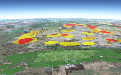
Sensitive areas show up as colored splotches on the online maps, allowing energy developers to steer clear of them when mulling where to break ground. “This technology will help in the very important effort to create precise maps to understand where wildlife feed, live, breed, and migrate, and where we should tread the most lightly in our effort to develop our energy resources," Wyoming Gov. Dave Freudenthal said in an NRDC press release.
 The Path to Green Energy tool online comes just as the feds dole out over energy funds from the stimulus package and states look to expand renewable energy production, which has already led to some bickering between enviros and developers. Sen. Diane Feinstein (D–Calif.), for instance, recently sponsored legislation to set aside hundreds of thousands of acres in the desert in southeastern California – a hotbed of planned solar and wind energy farms. The Path to Green Energy tool online comes just as the feds dole out over energy funds from the stimulus package and states look to expand renewable energy production, which has already led to some bickering between enviros and developers. Sen. Diane Feinstein (D–Calif.), for instance, recently sponsored legislation to set aside hundreds of thousands of acres in the desert in southeastern California – a hotbed of planned solar and wind energy farms.
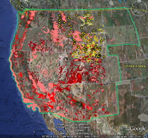
To help quell such quarrels, the map's creators have plans to identify those areas with the strongest winds and the sunniest days to optimize wind turbine and solar panel placements. The maps currently cover 860 million square miles (2.2 billion square kilometers) and include habitat data on 170 species, with more on the way, reports the San Francisco Chronicle.
Zoomed-in view of color-coded sensitive areas [top]. The whole western U.S. as shown on the Path to Green Energy on Google Earth [right]. Image credits: NRDC

|
 Map")