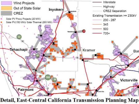
Renewable Energy Past and Present in California's TehachapiApr 26, 2010 - Herman K. Trabish - renewableenergyworld.comWorld.Com The Tehachapi Mountains in central California's Kern County are a wind energy museum. Four generations of turbines are distinguishable on their slopes and ridges, with an installed capacity of more than 800 megawatts of wind power. These hills are alive with the sound of wind power. Kern was once known as oil country and its rich fields supplied much of the oil that made California the oil capital of the U.S back in the 1920s and fueled the U.S. industry's mid-20th century boom. As Ed Duggan of wind developer Oak Creek Energy said, "Kern County knows energy." Kern knows that energy means wealth and so, as the last of its oil continues to play out, it is now turning excitedly to wind and sun and steam. On the bubble graphs of the most recent California Renewable Energy Transmission Initiative (RETI) report, no California bubble is even nearly as big with resource potential as the Tehachapi-Mojave area, and it is also among those positioned lowest in cost and least limited with environmental obstacles. (See map, below.) Veteran Kern County planner Lorelei Oviatt isn’t even completely sure how much renewable energy development is currently in the works because the boom has spilled over into neighboring San Bernardino and Los Angeles Counties. The rapidly expanding list of solar power project applications and plans includes as many as 63 developers because the Tehachapi-Mojave region’s insolation makes it one of the four best regions for solar development in the world. The definitive amount of proposed or planned wind is equally hard to pin down. In total CEC data suggests there are probably over 40,000 megawatts of proposed renewable projects. That’s two-thirds of California’s grid capacity and enough electricity to power over 20 million homes. One thing that is certain is that Terra-Gen is preparing ground for the first phase of its Alta-Oak Creek Mojave project and will soon begin putting up the first of 100 1.5-megawatt (MW) GE towers. Once the project is complete (in early 2011), it will boast 320 turbines of varying sizes and an estimated total of 800 MW of capacity. Many major wind developers including Alta Wind, Horizon Wind, Western Wind Energy, enXco and the L.A. Department of Water & Power are also making wind project plans. Transmission, Too That will only be the beginning. Windhub, an SCE transmission substation is being completed at the base of the Tehachapis directly across from the wind projects. It is expected to go online this year, completing the first 3 segments of SCE’s CPUC-approved 11-part Tehachapi Renewable Transmission Project (TRTP). It is an enormous undertaking that will ultimately carry 4,500 megawatts of wind, solar, geothermal and biomass power from the Tehachapi-Mojave area to the energy hungry Los Angeles region 200 miles to the southwest. The Benefits of Being First to the Table Kern’s foothill valleys have been, since the 19th century, ranch and farm country. But these days, ranchers and farmers are finding that sowing wind, solar and geothermal makes the economics of rural life more equitable, so Kern’s cattle now often graze nonchalantly beneath towering turbines. Many developers have been in the region for years, some for decades. Newcomers benefit from the on-going public dialogue that started back in the 1980s. After 30 years of development, everybody agrees where the right sites are, what the benefits of renewables are and what to expect when they see developers coming. According to both SCE’s Kathy Hart and the Kern Wind Industry Association’s Linda Parker, the U.S. Air Force at nearby Edwards Air Force Base has been so impressed by renewables that it has its own ambitious solar installation plans. Kern County was one of the first places in the U.S. to realize that proper planning precludes conflicts. When landowners and economic development associations started exploring the possibility of profiting from the prevailing winds, they turned up issues surrounding Air Force flight paths, avian migration lanes, precious wildlife habitat and neighbors disdainful of turbine sounds and impediments to their vistas. So the stakeholders got together and drew maps, redlining places where wind installations shouldn’t go, yellowing out places that might be problematic and greening in the places ideal for green energy and green profits. They also started petitioning, imploring and pushing for SCE to bring them new transmission. Then in 2004 when SCE was thinking about how to meet California’s 2002 Renewable Portfolio Standard (RPS), it remembered Tehachapi and decided to sit down and make plans with the CEC, the CPUC, county commissions, environmentalists and developers. It brought Kern country planner Oviatt, Oak Creek CEO Hal Romaonwitz and others who had been turning Kern County maps red, yellow and green for years to the table and from their talks, a detailed picture of a Renewable Energy Zone emerged. It became a veritable prototype for the kind of map a similar group of stakeholders drew up soon afterward for the CEC. A Template for U.S. Renewable Energy Zone Mapping The CEC’s maps evolved into California’s RETI, defining where the best and most economically accessible renewable resources are and what transmission routes most readily serve them. The still evolving RETI became the prototype for the Western Governors Association (WGA) Western Renewable Energy Zones (WREZ) Initiative. And that is essentially the template for maps the U.S. Department of Interior is now developing to streamline renewable energy growth and transmission development on the nation’s publicly owned lands. SCE expects to be ready to establish TRTP interconnections this fall.
Herman K. Trabish is a writes and edits NewEnergyNews and is a regular blogger for RenewableEnergyWorld.com.
|