|
|||||||
|
GENI offers a money-back guarantee on all products we sell. |
|||||||
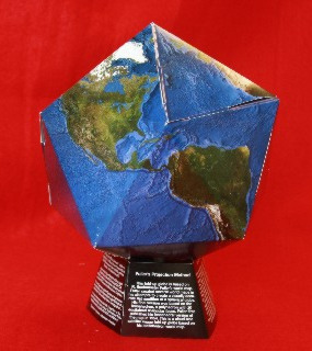
The Raleigh Edition of Fuller Projection Air-Ocean World Dymaxion Map |
|||||||

Don't waste another day looking at other distorted depictions of the earth! Dymaxion™ world maps, invented by R. Buckminster Fuller, are the world's most accurate flat global projection. It has at most a 2% distortion at any one place, so there is no visible distortion of relative shapes and sizes of the land and sea areas. Fuller’s Raleigh Edition World Dymaxion Map includes major rivers, cities, and color-coded mean low temperature gradients for both land and water, making this map of the continents a must have for social science and geography teachers to have in the classroom. Students will enjoy this unique visual representation of the world which shows the Earth’s landmasses without any breaks in the continental contours, emphasizing the connections between continents, cultures, and climate. A map collection would not be complete without adding this air-ocean portrayal. Enjoy this beautiful four-color 34" X 22" (86cm X 56cm) vector
poster, printed on heavy-gauge paper. It's perfect to be framed or laminated [Editor's NOTE: we have a limited supply of pre-laminated maps in stock at this low price]. (Edges of icosa triangles equal to: 1:47,000,000 scale; 63° 26'; 3,806 nautical miles; 8.5 jet aircraft hours; 7 ship days). R. Buckminster Fuller and Shoji Sadeo, Cartographers. (U.S. Patent 2,393,676) Published by The Student Publications of the School of Design, North Carolina State College, Raleigh, NC, USA This entire map and its component parts and method of projection are fully protected by international copyright convention and patents and must not be reproduced without permission of R. Buckminster Fuller. This edition of Fuller projection licensed by him under his U.S. Patent 2,393,676, Canadaian Patent 448,064 and his copyrights of 1943, 1944, 1953, 1954, 1967, 1971, 1980. This edition is copyrighted by him © 1982. |
|||||||
|
Price: $20.00 | Add to Cart |
|||||||
|
|||||||
|
GENI offers a money-back guarantee on all products we sell.
|
|||||||