 <<back || index || next>> |
||||||||||||||||||||||||||||||||||||||||||||||||||||||||||||||||||||||||||||||||||||||||||||||||||||||||||||||||||||||||||||||||||||||||||||||||||||||||||||||||||||||||||||||||||||||||||||||||||||||||||||||||||||||||||||||||||||||||||||||||||||||||||||||||||||||||||||||||||||||||||||||||||||||||||||||||||||||||||||||||||||||||||||||||||||||||||||||||||||||||||||||||||||||||||||||||||||||||||||||||||||||||||||||||||||||||||||||||||||||||||||||||||||||||||||||||||||||||||||||||||||||||||||||||||||||||||||||||||||||||||||||||||||||||||||||||||||||||||||||||||||||||||||||||||||||||||
| Chapter Contents | |
| Geography | 1.1 |
|
1.1 |
|
|
1.1 |
|
|
1.1 |
|
|
Planned Capacity |
|
|
1.2 |
|
| 1.2 | |
| 1.3 | |
| Vulnerable/Endangered Ecoregions | 1.6 |
| Geographic Location of Ecoregions | 1.7 |
| Population Distribution | 1.8 |
| References | 1.9 |
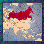
Russia (Eastern Russia)
GEOGRAPHY
- Northern Asia (that part west of the Urals is sometimes included with Europe), bordering the Arctic Ocean, between Europe and the North Pacific Ocean
- Geographic Coordinates: 60 00 N, 100 00 E
- Area: total: 17,075,200 sq km (land: 16,995,800 sq km; water: 79,400 sq km)
(CIA: The World Factbook 2002: http://www.cia.gov/cia/publications/factbook/index.html)
GEODYNAMICS
- Several areas in the former Soviet republics are near plate margins. The subduction boundary at Kamchatka north of Japan is part of the "ring of fire"
(GEO: http://geothermal.marin.org/map/russia.html)
- A chain of over fifty islands separating the Sea of Okhotsk from the Pacific Ocean was formed from volcanic activities from the Miocene-Pliocene and Mid-Pleistocene.
- Within the Alpine folding zone of the Pacific Ocean Geosyncline (Nalivkin 1960) and is largely the result of subduction by the Pacific Plate under the Eurasian Plate
(WWF: http://www.worldwildlife.org/wildworld/profiles/terrestrial/pa/pa0438_full.html)
- Kamchatcka :
- Far eastern Siberian peninsula
- Abundant volcanoes, above northward extension of Kurils subduction zone
- Kuril Islands :
- Subduction of Pacific Plate below North American Plate
- Back arc spreading in Sea of Okhotsk
- Extends north as Kamchatka, south into Hokkaido
(Acadia University: http://ace.acadiau.ca/science/geol/rraeside/quizzes/world-notes.htm)
ELECTRICITY
- Electric Installed Capacity (2000E): 203 gigawatts
- Thermal:68%, Hydro: 21.5%, Nuclear:10.5%
- Electricity Generation (2000E): 836 billion kilowatt-hours (Bkwh)
- Electricity Consumption (2000E): 767 Bkwh
- Net Electricity Exports (2000E): 69 Bkwh
(EIA: http://www.eia.doe.gov/emeu/cabs/russia.html)
GEOTHERMAL ELECTRICITY GENERATION
- Some geothermal expansion in the Kamchatka Peninsula and the Kurile Islands (1994-1999)
- 32MWe, 4 MWe, and 20MWe power plants in the Kurile Islands planed (2000-2003)
Installed geothermal generating
capacity
|
|
|
Pauzhetka |
11 |
|
Verkhne |
12 |
|
Total |
23 |
(IGA: http://iga.igg.cnr.it/russia.php)
GEOTHERMAL ENERGY IN EASTERN RUSSIA
|
|
Water temperature: 400-2000C |
Water temperature: 500-2000C |
||||
|
Output |
Output mln. m3 |
Possible economy of fuel and heat per year
mln. t.c.e. |
Output |
Output |
Possible economy of fuel and heat per year
mln. t.c.e. |
|
|
Eastern Siberia, |
3.35 |
1222.75 |
8.50 |
1.36 |
492 |
3.42 |
|
Yakutia, Magadan, Habarovsk, |
1.65 |
602.25 |
4.20 |
0.66 |
240 |
1.67 |
|
Kamchatka, |
1.70 |
620.50 |
4.30 |
0.7 |
252 |
1.75 |
(Black Sea Regional Energy Center, http://www.bsrec.bg/opet/russia/Geo_Russia.htm)
GEOTHERMAL POTENTIAL
CONSIDERATIONS
WORLD HERITAGE
- Lake Baikal
- Volcanoes of Kamchatka
(UNESCO: http://whc.unesco.org/sites/natural.htm)
NATIONAL PARKS AND RESERVATIONS
National Parks of Russia
(last modified 15 January 2002)
|
National Park |
Location |
Area (km2) |
Year Established |
|
Bashkiria |
Bashkortostan |
832 |
1986 |
|
Chuvash Varmane |
Chuvashia |
252 |
1993 |
|
Kenozersky |
Arkhangelskaya |
1392 |
1991 |
|
Khvalynsky |
Saratovskaya |
? |
1994? |
|
Kurshskaya Kosa |
Kaliningradskaya |
66.21 |
1987 |
|
Losiny Ostrov |
Moscowskaya |
111.44 |
1983 |
|
Mariya Chodra |
Maree El |
366 |
1985 |
|
Meschersky |
Ryazanskaya |
1030 |
1992 |
|
Meschora |
Vladimirskaya |
1187.58 |
1992 |
|
Nizhnaja Kama |
Tatarstan |
261 |
1991 |
|
Orlovskoe Polesye |
Orlovskaya |
47.78 |
1994 |
|
Paanayarvi |
Karelia |
1033 |
1992 |
|
Pereslavsky |
Yaroslavskaya |
217 |
1988 |
|
Pribaikalsky |
Irkutskaya |
4127.42 |
1986 |
|
Prielbrussky |
Kabardino-Balkariya |
1004 |
1986 |
|
Pripyshmenskie Bory |
Ekaterinburgskaya |
490 |
1993 |
|
Russkiy Sever |
Vologodskaya |
1664 |
1992 |
|
Samarskaya Luka |
Samarskaya |
1280 |
1984 |
|
Sebezhsky |
Pskovskaya |
480 |
1995 |
|
Shorsky |
Kemerovskaya |
4180 |
1989 |
|
Shushensky Bor |
Krasnoyarsk region |
104 |
1995 |
|
Smolenskoe Poozerye |
Smolenskaya |
1462 |
1992 |
|
Smolny |
Mordovia rep. |
? |
1994? |
|
Sochinsky |
Krasnodarsky Krai |
1900 |
1983 |
|
Taganai |
Cheliabinskaya |
564 |
1991 |
|
Tunkinsky |
Buryatia |
11836 |
1991 |
|
Ugra |
Kaluzhskaya |
540 |
1996 |
|
Valdaisky |
Novgorodskaya |
1585 |
1990 |
|
Vodlozersky |
Karelia, Arkhangelskaya |
4047 |
1991 |
|
Yugyd Va |
Komi |
18917.01 |
1993 |
|
Zabaikalsky |
Buryatia |
2693 |
1986 |
|
Zjuratkul |
Chelyabinskaya |
868 |
1994 |
Zapovednik (Nature Preserves)
|
Zapovednik |
Location |
Area (km2) |
Year Established |
|
Altaisky |
Altayskij krai |
8812.38 |
1932 |
|
Astrakhansky |
Astrakhansky |
668.16 |
1919 |
|
Azas |
Tuva republic |
3372.9 |
1985 |
|
Baikalo-Lensky |
Irkutskaya |
6599.19 |
1986 |
|
Baikalsky |
Buryat republic |
1657.24 |
1969 |
|
Barguzinsky |
Buryat republic |
3744.23 |
1916 |
|
Bashkirsky |
Bashkortostan |
496.09 |
1930 |
|
Bassegi |
Permskaya |
379.57 |
1982 |
|
Bastak |
Jewish auton. region |
910 |
1997 |
|
Bolshaya Kokshaga |
Maree El rep. |
214 |
1993 |
|
Bolshekhekhtsirsky |
Khabarovsky |
451.23 |
1963 |
|
Botchinsky |
Khabarovsky |
2673.8 |
1994 |
|
Bryansky Les |
Bryanskaya |
121.68 |
1987 |
|
Bureinsky |
Khabarovsky |
3584.44 |
1987 |
|
Chazy |
Khakasskaya |
241.41 |
1991 |
|
Chernye Zemli |
Kalmykiya |
1250 |
1990 |
|
Dagestansky |
Dagestan rep |
190.61 |
1987 |
|
Dalnevostochny |
Primorsky krai |
643.16 |
1978 |
|
Darvinsky |
Vologodskaya |
1126.73 |
1945 |
|
Daursky |
Chitinskaya |
447.52 |
1987 |
|
Denezhkin Kamen |
Ekaterinburgskaya |
781.92 |
1991 |
|
Dzerginsky |
Buryat rep. |
2378.06 |
1992 |
|
Dzhugdzhursky |
Khabarovsky krai |
8062.56 |
1990 |
|
Galichia Gora |
Lipetskaya |
2.31 |
1925 |
|
Great Arctic |
Krasnoyarsky krai |
41692.22 |
1993 |
|
Gydansky |
Yamalo-Nenetsky unit |
8780 |
1996 |
|
Ilmesnky |
Cheliabinskaya |
303.8 |
1920 |
|
Kabardino-Balkarsky |
Kabardino-Balkaria |
740.99 |
1976 |
|
Kaluzhskie Zaseki |
Kaluzhskaya |
185.33 |
1992 |
|
Kandalakshsky |
Murmanskaya |
705.27 |
1932 |
|
Katunsky |
Altaisky krai |
1500.79 |
1991 |
|
Kavkazsky |
Krasnodarsky krai |
2632.77 |
1924 |
|
Kedrovaja Pad |
Primorsky krai |
178.97 |
1925 |
|
Kerzhensky |
Nizhegorodskaya |
469.4 |
1993 |
|
Khankaisky |
Primorsky krai |
379 |
1990 |
|
Khingansky |
Amurskaya |
978.36 |
1963 |
|
Khopersky |
Voronezhskaya |
161.78 |
1935 |
|
Kivach |
Karelia |
108.8 |
1931 |
|
Komandorsky |
Kamchatskaya |
36486.79 |
1993 |
|
Komsomolsky |
Khabarovsky krai |
638.66 |
1963 |
|
Koryaksky |
Kamchatka |
3271.67 |
1995 |
|
Kostomukshsky |
Karelia |
474.57 |
1983 |
|
Kronotsky |
Kamchatskaya |
10990 |
1934 |
|
Kurilsky |
Sakhalinskaya |
653.65 |
1984 |
|
Kuzneztky Alatau |
Kemerovskaya |
4555 |
1989 |
|
Laplandsky |
Murmanskaya |
2684.36 |
1930 |
|
Lazovsky |
Primorsky krai |
1200.24 |
1957 |
|
Les na Vorskle |
Belgorodskaya |
11.28 |
1979 |
|
Magadansky |
Magadanskaya |
8838.05 |
1982 |
|
Malaya Sozva |
Tyumenskaya |
2255.62 |
1976 |
|
Maly Abakan |
Khakasskaya |
978.29 |
1993 |
|
Mordovsky |
Mordovia rep. |
321.48 |
1936 |
|
Nurgush |
Kirovskaya |
59.19 |
1994 |
|
Nyzhnesvirsky |
Leningradskaya |
416 |
1980 |
|
Oksky |
Ryazanskaya |
557.31 |
1935 |
|
Olekminsky |
Yakutia rep. |
8471.08 |
1984 |
|
Orenburgsky |
Orenburgskaya |
216 |
1989 |
|
Pasvik |
Murmanskaya |
147.27 |
1992 |
|
Pechoro-Ilychsky |
Komi rep. |
7213.22 |
1930 |
|
Pinezhsky |
Arkhangelskaya |
412.44 |
1974 |
|
Polistovsky |
Pskovskaya |
360.25 |
1994 |
|
Poronaisky |
Sakhalinskaya |
566.94 |
1988 |
|
Prioksko-Terrasny |
Moskovskaya |
49.45 |
1935 |
|
Prisursky |
Chuvash republic |
90.25 |
1995 |
|
Privolzhsk Lesostep |
Penzenskaya |
83.08 |
1989 |
|
Putoransky |
Krasnoyarsky krai |
18873 |
1988 |
|
Rdeisky |
Novgorodskaya |
359.22 |
1994 |
|
Rostovsky |
Rostovskaya |
94.64 |
1995 |
|
Sayano-Shushensky |
Krasnoyarsky krai |
3903.68 |
1976 |
|
Severo-Osetinsky |
Severnaya Osetiya |
289.99 |
1967 |
|
Shulgan Tash |
Bashkortostan |
225 |
1986 |
|
Sikhote-Alinsky |
Primorsky krai |
3470.52 |
1935 |
|
Sokhondinsky |
Chitinskaya |
2110.07 |
1973 |
|
Stolby |
Krasnoyarsky krai |
471.54 |
1925 |
|
Taimyrsky |
Krasnoyarsky krai |
17819.28 |
1979 |
|
Teberdinsky |
Karachaevo-Cherkessia |
849.96 |
1936 |
|
Tsentralno-Chernozemny |
Kurskaya |
48.74 |
1935 |
|
Tsentralno-Lesnoy |
Tverskaya |
213.8 |
1931 |
|
Tsentralno-Sibirsky |
Krasnoyarsky krai |
9720.17 |
1985 |
|
Tungussky |
Yakutia rep. |
2965.62 |
1995 |
|
Ubsunurskaya Kotlovina |
Tuva rep. |
396 |
1993 |
|
Ussurijsky |
Primorsky krai |
404.32 |
1932 |
|
Ust Lensky |
Yakutia rep. |
14330 |
1985 |
|
Verkhne-Tazovsky |
Tyumenskaya |
6313.08 |
1986 |
|
Vishersky |
Permskaya |
2412 |
1990 |
|
Visimsky |
Ekaterinburgskaya |
135.06 |
1971 |
|
Vitimsky |
Irkutskaya |
5850.21 |
1982 |
|
Volzhsko-Kamsky |
Tatarstan rep. |
80.34 |
1960 |
|
Voronezhsky |
Voronezhskaya |
310.53 |
1927 |
|
Voroninsky |
Tambovskaya |
108.19 |
1994 |
|
Wrangel Island |
Magadanskaya |
7956.5 |
1976 |
|
Yugansky |
Tyumenskaya |
6228.86 |
1982 |
|
Yuzhno-Uralsky |
Chelyabinskaya |
2549.14 |
1978 |
|
Zeysky |
Amurskaya |
993.9 |
1963 |
|
Zhigulevsky |
Samarskaya |
231.4 |
1927 |
(Johnston’s Archive: http://www.johnstonsarchive.net/other/natpk-russia.html)
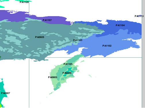
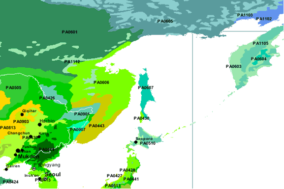
VULNERABLE/ENDANGERED ECOREGIONS
- South Sakhalin-Kurile mixed forests (PA0438)
- Ussuri broadleaf and mixed forests (PA0443)
- Da Hinggan-Dzhagdy Mounains conifer forests (PA0505)
- Sayan montane conifer forests IPA0519)
- East Siberian taiga (PA0601)
- Okhotsk-Manchurian taiga (PA0606)
- Sakhalin Island taiga (PA0607)
- Trans-Bikal conifer forests (PA0609)
- Mongolian-Manchurian grassland (PA0813)
- Amur meadow steppe (PA0901)
- Suiphun-Khanka meadows and forest meadows (PA0907)
- Trans-Baikal Bald Mountain tundra (PA1112)
(WWF: http://www.worldwildlife.org/wildworld/profiles/terrestrial/pa/pa0438_full.html)
GEOGRAPHIC LOCATIONS OF ECOREGIONS
POPULATION DISTRIBUTION
- Estimate: 147.5 – 149.9 million in 1995
- 78% lives in the European part of Russia
- Most of industrial cities in the European part
- Moscow 8.7 million [1992]
- St. Petersburg 4.4 million
- Novosibirsk: 1.4 million
- Nizhniy Novgorod: 1.4 million
- Yekaterinburg: 1.4 million
- Samara: 1.2 million
- Omsk: 1.2 million
- Chelyabinsk: 1.1 million
- Kazan 1.1 million
- Only Novosibirsk and Omsk located east of the Urals
- Distribution varies from more than 200 to 0.03 person per square kilometer
(University of Louisvill Ekstrom Library Government Publications: http://lcweb2.loc.gov/cgi-bin/query/r?frd/cstdy:@field(DOCID+ru0064))
References
- Acadia University. Significant places for global
tectonics. Retrieved from world wide web: http://ace.acadiau.ca/science/geol/rraeside/quizzes/world-notes.htm
(October 24, 2002)
- Black Sea Regional Energy Center. Geothermal energy
in Russia. Retrieved from world wide web: http://www.bsrec.bg/opet/russia/Geo_Russia.htm
(September 10)
- Central Intelligence Agency (CIA). (January 2002).
The world factbook 2002 – Russia. Retrieved from
world wide web: http://www.cia.gov/cia/publications/factbook/index.html
(September 10, 2002)
- Energy Information
Administration (EIA). (November 2002). Retrieved
from world wide web: http://www.eia.doe.gov/emeu/cabs/russia.html
(November 24, 2002)
- Geothermal Education Office (GEO). Russia. Retrieved
from world wide web: http://geothermal.marin.org/map/russia.html
(September 10, 2002)
- International Geothermal Association (IGA). (May
2002). Welcome to our page with data for Russia.
Retrieved from world wide web:
http://iga.igg.cnr.it/russia.php (October 2,
2002)
- Johnston’s Archive. National parks in Russia.
(January 2002). Retrieved from world wide web: http://www.johnstonsarchive.net/other/natpk-russia.html
(September 11, 2002)
- National Geographic. Wild World – Terrestrial
ecoregions of the world. Retrieved from world wide
web: http://www.nationalgeographic.com/wildworld/terrestrial.html?id=1&mapServiceName=WW_Terrecos&locWidth=120&locHeight=72&cMinx=141.8004&cMiny=45.914108
&cMaxx=142.666901&cMaxy=47.798401&size=small&detail=detailed?id=1&size=small&detail=detailed&cMinx=142.23&cMiny=41&cMaxx=185.43&cMaxy=69.13 (Septmeber 12, 2002)
- United Nation Educational, Scientific, and Cultural
Organization (UNESCO). National properties on the
world heritage list. (July 1, 2002). Retrieved from
world wide web: http://whc.unesco.org/sites/natural.htm
(October 24, 2002)
- University of Louisvill Ekstrom Library Government
Publications. Russia population Statistics (in Russia:A
country study). Retrieved from world wide web: http://lcweb2.loc.gov/cgi-bin/query/r?frd/cstdy:@field(DOCID+ru0064)
(December 27, 2002)
- World Wildlife Fund (WWF). Ecoregions. Retrieved from world wide web: http://www.worldwildlife.org/wildworld/profiles/terrestrial/pa/pa0438_full.html (October 20, 2002)