|

Library >>
Renewable Energy Resource
Maps >> North America
>> Wind >> USA
Wind Energy Potential in the USA
http://rredc.nrel.gov/wind/pubs/atlas/maps/chap2/2-01m.html
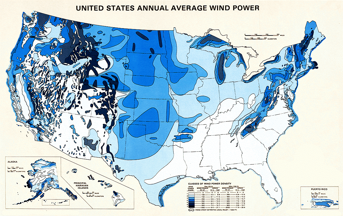
Wind Energy Resource Potential
Good wind areas, which cover 6% of the contiguous
U.S. land area, have the potential to supply more
than one and a half times the current electricity
consumption of the United States.
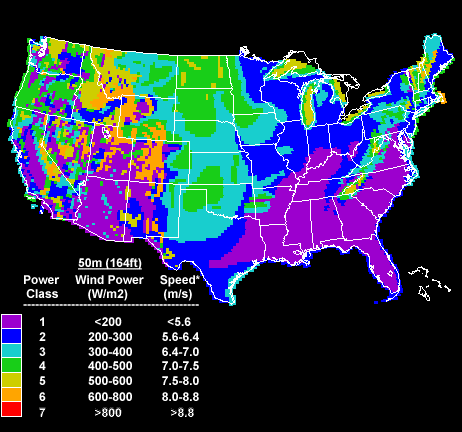
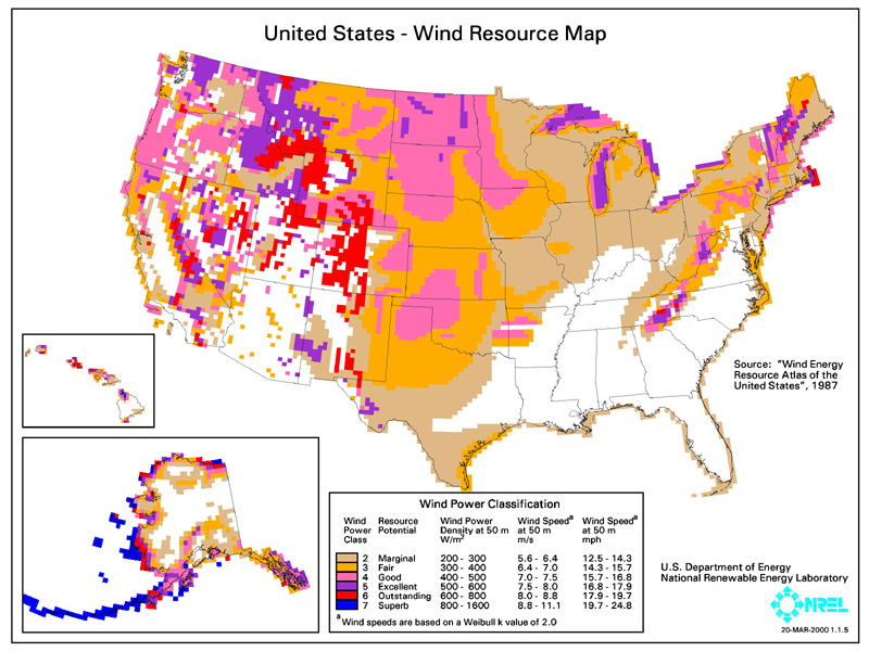
Estimates of the wind resource are expressed in
wind power classes ranging from class 1 to class
7, with each class representing a range of mean
wind power density or equivalent mean speed at specified
heights above the ground. Areas designated class
4 or greater are suitable with advanced wind turbine
technology under development today. Power class
3 areas may be suitable for future technology. Class
2 areas are marginal and class 1 areas are unsuitable
for wind energy development.
http://www1.eere.energy.gov/windandhydro/wind_potential.html
Strong, frequent winds are ideal for generating
electricity. The best resource areas are shown on
maps incorporating wind speeds based on measurements
taken throughout the year at monitoring stations
and on estimations coming from the newest meteorological
models.
For a specific location, annual average wind speed
is used to calculate the amount of energy in the
wind blowing through a wind turbine's rotor per
square meter of area. This is expressed as watts
per square meter. From this calculation of the energy
available in the wind, geographic areas as small
as one square mile are assigned a wind power class
from 1 to 7.
State officials and developers use this information
to find the best areas for wind development. Sites
in wind power class 3 or higher are candidates for
wind farm development. Class 2 sites or higher offer
possibilities for adding small wind generators.
http://www.nrel.gov/wind/wind_map.html
http://ocsenergy.anl.gov/documents/docs/NREL_Scoping_6_06_2006_web.pdf
Renewable
Potential Maps (EIA)
Renewable Potential Maps present an integrated
picture of renewable energy resources in each U.S.
Census Division. Solar, geothermal, and wind energy
potentials and indicators of hydroelectric and biomass
energy potentials (fuelwood harvested, rivers, and
precipitation) are presented.
The Renewable Potential Map series includes maps
of each of the nine U.S. Census Divisions and individual
State maps of Alaska, California, and Hawaii.
Regions/ States
Alaska | California
| New England | East North Central Division | East
South Central Division | Hawaii
| Middle Atlantic | Mountain Division | Pacific Division
| South Atlantic | West North Central Division | West
South Central Division
Alaska | Alabama
| Arizona | Arkansas | California | Connecticut |
Colorado | Delaware | Florida | Georgia | Hawaii
| Idaho | Illinois | Indiana | Kansas | Kentucky |
Louisiana | Maine | Maryland | Massachusetts | Michigan
| Minnesota | Mississippi | Missouri | Montana | Nebraska
| Nevada | New Hampshire | New Jersey | New Mexico
| New York | North Carolina | North Dakota | Ohio
| Oklahoma | Oregon | Pennsylvania | Rhode Island
| South Carolina | South Dakota | Tennessee | Texas
| Washington | Wisconsin | Wyoming | Utah | Vermont
| Virginia | West Virginia
Related GENI Resources
Links
|