|
COMMONLY
ASKED QUESTIONS ABOUT THE FULLER PROJECTION:
What
is meant by 'no visual distortion?'
When
transferring geographic data from the globe onto a
flat plane, distortions will always occur in either
shape, size, area, distance or direction.
On
projections such as the Mercator map, the further
north of south of the equator one goes, the more extreme
the distortion becomes. When comparing the Mercator
map to a globe, it is easy for everyone to see that
Greenland, for example, is much larger on the flat
Mercator map than it is on the globe.
However,
when visually comparing land masses on Fuller's map
to that of a globe, the land masses appear to have
their correct size.
The
Peters projection, on the other hand, sacrifices shape
to preserve relative accuracy in overall land area;
distortions are obvious when comparing it to the globe.
However, there are no visible shape discrepancies
in any of the land masses on Fuller's map when it
is compared to a globe.
Minute
area and shape distortions can be detected mathematically
and are equally distributed throughout the map. Visually,
however, these distortions are negligible.
Why
an icosahedron?
A
polyhedron is a many-sided 3-dimensional object. An
icosahedron is a polyhedron with 20 equilateral triangular
faces. Of the five Platonic polyhedra (all of which
have equal faces in size and shape), the icosahedron
most closely approximates a sphere.
Fuller
found that the best way to lay various polyhedra flat
while keeping all the land masses unbroken was to
use the icosahedron. With only two exceptions, all
the breaks needed to lay the icosahedron flat occur
completely within the oceans, and, therefore, keeps
the division of land masses to a minimum.
With
minor adjustments to two triangular faces, Fuller's
Dymaxion Air-Ocean World Map provides us with a flat
view of all the Earth's land masses as unbroken islands
in a single world ocean.
Why
are the oceans broken up?
Try
peeling an orange while keeping the skin in one piece.
Then lay the skin out flat. Notice how it needs breaks,
or 'sinuses' in many different places in order to
lay flat. The more breaks introduced, the flatter
the orange peel will lay.
When
an icosahedron is unfolded and laid flat, breaks need
to be introduced, just as in the case of the orange
peel. The question is then where to introduce these
breaks? One way of doing this is to introduce the
breaks in the oceans as much as possible. This provides
a world view in which the land masses are unbroken.
Fuller's
map was actually designed to have all of the icosahedron's
triangles separable. This allowed the map to be dynamic.
By rearranging the triangles, with the South Pole
at the center of the map, navigation routes by sea
become readily apparent, just as air routes across
the North Pole are obvious in the original configuration.
Fuller
explored more than 25 different useful configurations
of the Dymaxion Air-Ocean World Map. Each configuration
introduces breaks in different places and allows different
aspects of the world to be emphasized.
Why
are the mean low temperature zones shown?
The
Fuller Projection defines our world not in terms of
political boundaries or physical features but by temperature
zone. Buckminster Fuller was interested in the history
of human migration and the geographical areas of technological
innovation as it related to temperature.
Looking
at the yellow band closest to the North Pole we find
that the mean low temperature ranges from 23 degrees
to 41 degrees Fahrenheit. Fuller found that throughout
history, humans migrated east to west along the 32
degree freezing line and that the majority of the
dominant centers of modern civilization can be found
to lie somewhere within this optimum temperature band.
He felt that social patterns, human preoccupations
and economic customs are determined by how cold it
gets, not by how hot.
Buckminster
Fuller then realized that: (I ) the colder an area
gets the larger the fluctuation in temperature is
to be found, and (2) the more a geographical area's
temperature varies, the more technologically inventive
must humans living there become in order to survive.
(For example, they must learn to build boats to cross
a lake in summer, as well as design sleds to cross
the ice in winter.)
FULLER'S
PROJECTION METHOD
Fuller
superimposed a spherical icosahedron grid onto the
Earth's sphere. Each of the grid's edges are arcs
of "Great Circles" which show the shortest routes
between two points on a sphere's surface. 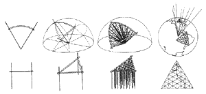
When
the Great Circle arcs are unfolded, the arc-edges
of the spherical icosahedron become the straight edges
of the regular icosahedron and the twenty spherical
triangles become twenty plane triangles. Since the
arc-edges are unfolded, their lengths remain undistorted.
Minute distortion in the middle of each triangle is
distributed evenly throughout the map.
The
Fuller Projection is not a 'shadow' projection as
most maps are because the world is not projected'
onto a regular icosahedron but rather unfolds into
an icosahedron. Thus, Fuller preferred to call his
map a "transformation". During this transformation,
the line from the sphere's center through the sphere's
surface and out to the zenith point is kept at a constant
90 degree angle with respect to the map's surface.
Fuller referred to this as a "constant zenith projection."
©
1992 Buckminster Fuller institute, Los Angeles
For more information, please contact:
Buckminster Fuller Institute
1 743 South La Cienega Blvd.
Los Angeles, CA 90035
Phone (310) 837-7710, Fax (310) 837-7715

|