 <<back || index || next>>
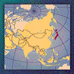
Japan
JapanGEOGRAPHY
(CIA: The World Factbook 2001: http://www.cia.gov/cia/publications/factbook/index.html) GEODYNAMICS
(GEO: http://geothermal.marin.org/map/japan.html)
(The Natural World of Japan: http://www.seinan-gu.ac.jp/~djohnson/natural/geology.html)
(Acadia University: http://ace.acadiau.ca/science/geol/rraeside/quizzes/world-notes.htm) ELECTRICITY
(EIA: http://www.eia.doe.gov/emeu/cabs/japan.html) GEOTHERMAL ELECTRICITY GENERATION
(IGA: http://iga.igg.cnr.it/japan.php)
(IGA: http://iga.igg.cnr.it/japan.php)
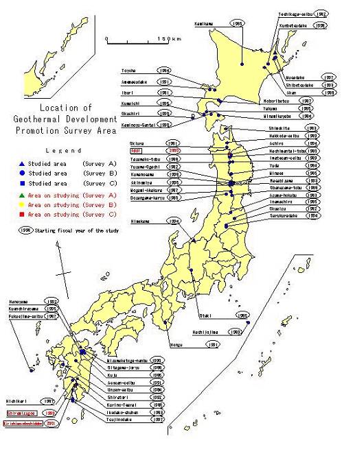
(GEO: http://geothermal.marin.org/map/japan.html) GEOTHERMAL POTENTIALGeothermal Development Promotion Survey
(NEDO: http://www.nedo.go.jp/chinetsu/sokushin/indexe.htm)
Division of Geothermal Development
Promotion Survey Districts
|
|||||||||||||||||||||||||||||||||||||||||||||||||||||||||||||||||||||||||||||||||||||||||
|
Highest temperature in a district |
Number of districts |
District |
|
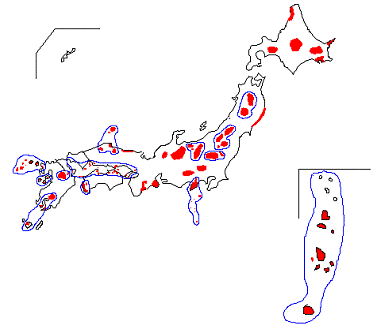
Districts where temperatures exceeding 200oC have been confirmed |
34 districts |
Hachimanntai-tobu, Dozangawa-karyu, Kurino-Tearai, Iburi, Yuzawa-Ogachi, Okuaizu, Shimokita, Azuma-hokubu, Toyoha, Unzenn-seibu, Kamikawa, Kuju, Yakumo, Minase, Inawashiro, Noboribetsu, Akan, Tazawako-tobu, Hakkoda-seibu, Iwatesan-seibu, Hachijojima, Mizuwaketoge-nanbu, Amemasudake, Asosan-seibu, Sarukuradake, Shiratori, Shibetsudake, Wasabizawa, Ashiro, Kumaishi, Musadake, Akinomiya, Tsujinodake, Kuwanosawa |
|
Districts where temperatures of 180oC to 200oC have been confirmed |
3 districts |
Minamikayabe, Okushiri, Kaminoyu-Santai |
|
Districts where temperatures of 150oC to 180oC have been confirmed |
3 districts |
Okiura,Yuda, Himekawa |
|
Districts where temperatures of 100oC to 150oC have been confirmed |
7 districts |
Teshikaga-seibu, Ikedako-shuhen, Hishikari, Obanazawa-tobu, Oitagawa-joryu, Hongu, Haneyama |
|
Districts with temperatures below 100oC |
5 districts |
Otaki, Mogami-Akakura, Fukuejima-seibu, Kuenohirayama, Kunbetsudake |
|
Total |
52 districts |
|
(NEDO: http://www.nedo.go.jp/chinetsu/sokushin/indexe.htm)
(NEDO: http://www.nedo.go.jp/chinetsu/dgrs/indexe.htm)
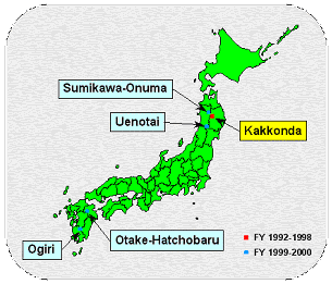
- Kakkonda geothermal field: higher than 500° C
CONSIDERATIONS
WORLD HERITAGE
- Yakushima
- Shirakami-Sanchi
(UNESCO: http://whc.unesco.org/sites/natural.htm)
NATIONAL PARKS AND RESERVES
Quasi-national parks in Japan
(Tamagawa University: www.tamagawa.ac.jp/.../harker/forest/destruction.htm)
VULNERABLE/ENDANGERED ECOREGIONS
- Hokkaido deciduous forests (PA0423)
- Nihonkai evergreen forests (PA0427)
- Nihonkai montane deciduous forests (PA0428)
- Taiheiyo evergreen forests (PA0440)
- Taiheiyo montane deciduous forests (PA0441)
- Hokkaido montane conifer forests (PA0510)
- Honshu alpine conifer forests (PA0511)
- Nansei Islands subtropical evergreen forests (IM0170)
(WWF: http://www.worldwildlife.org/wildworld/profiles/terrestrial_pa.html)
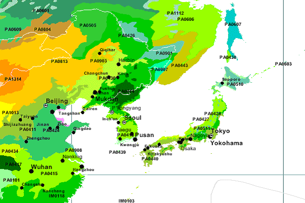
GEOGRAPHIC LOCATION OF ECOREGIONS
POPULATION DISTRIBUTION
|
|
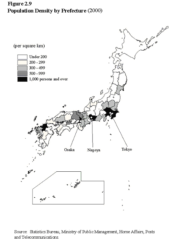
(Statistics Bureau & Statistics Center: http://www.stat.go.jp/english/data/handbook/c02cont.htm#cha2_6)
References
- Acadia University. Significant places for global
tectonics. Retrieved from world wide web: http://ace.acadiau.ca/science/geol/rraeside/quizzes/world-notes.htm
(October 24, 2002)
- Central Intelligence Agency (CIA). (January 2002).
The world factbook 2002 � Japan. Retrieved from
world wide web: http://www.cia.gov/cia/publications/factbook/index.html
(September 10, 2002)
- Energy Information Administration (EIA). (May
2002). Country analysis briefs � Japan. Retrieved
from world wide web:
http://www.eia.doe.gov/emeu/cabs/japan.html
(October 2, 2002)
- Geothermal Education Office (GEO). (October 1997).
Japan. Retrieved from world wide web :
http://www.geothermal.marin.org/map/japan.html
(September 10, 2002)
- International Geothermal Association (IGA). (May
9, 2002). Welcome to our page with data for Japan.
Retrieved from world wide web:
http://iga.igg.cnr.it/japan.php (October
2, 2002)
- Ministry of the Environment (March 1997). Protection
of endangered species. Retrieved from world wide
web: http://www.env.go.jp/en/jeg/biodiv/species.html
(October 2, 2002)
- National Geographic. Wild world � Terrestrial
ecoregions of the world. Retrieved from world wide
web: http://www.nationalgeographic.com/wildworld/terrestrial.html?id=1&mapServiceName=
WW_Terrecos &locWidth=120&locHeight=72&cMinx=141.8004&cMiny=45.914108&cMaxx=
142.666901 &cMaxy=47.798401&size=small&detail=detailed?id=1&size=small&detail=
detailed &cMinx=142.23&cMiny=41&cMaxx=185.43&cMaxy=69.13 (October 20, 2002)
- Natural World of Japan, The. Retrieved from world
wide web: http://www.seinan-gu.ac.jp/~djohnson/natural/geology.html
(October 1, 2002)
- New Energy and Industrial Technology Development
Organization (NEDO). Deep-seated geothermal resources
survey. Retrieved from world wide web: http://www.nedo.go.jp/chinetsu/dgrs/indexe.htm
(September 20, 2002)
- New Energy and Industrial Technology Development
Organization (NEDO). Geothermal development promotion
survey. Retrieved from world wide web: http://www.nedo.go.jp/chinetsu/sokushin/indexe.htm
(September, 10, 2002)
- New Energy and Industrial Technology Development
Organization (NEDO). Division of geothermal development
promotion survey districts by the highest temperature.
Retrieved from world wide web: http://www.nedo.go.jp/chinetsu/sokushin/indexe.htm
(September, 10, 2002)
- Statistics Bureau & Statistics Center (2002).
Population density and regional distribution. Retrieved
from world wide web: http://www.stat.go.jp/english/data/handbook/c02cont.htm#cha2_6
(October 2, 2002)
- Tamagawa Universtiy. Quasinational park in Japan.
Retrieved from world wide web: www.tamagawa.ac.jp/.../harker/
forest/destruction.htm (September 17, 2002)
- United Nation Educational, Scientific, and Cultural
Organization (UNESCO). (July 1, 2002). Natural properties
on the world heritage list. Retrieved from world
wide web: http://whc.unesco.org/sites/natural.htm
(October 24, 2002)
- World Wildlife Fund (WWF). Ecoregions. Retrieved from world wide web: http://www.worldwildlife.org/wildworld/profiles/terrestrial_pa.html (October 24, 2002)