|

Library >>
Renewable Energy Resource
Maps >> North America
>>Geothermal >>
USA
Geothermal Energy in the USA
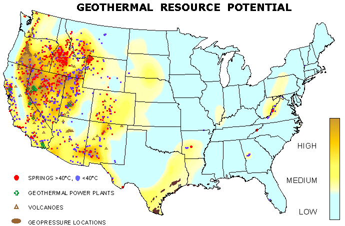
This Geothermal Resource Potential map was produced
using the Southern Methodist University Geothermal
Laboratory two databases: Western Geothermal Data
and Heat Flow Data. The data gradients, thermal
conductivities, heat flow and depth to maximum temperature
were all used to create this map. Spring and volcano
locations are from the USGS. The geopressure locations
are from the Department of Energy (DOE) map "Known
Potential Areas for Geothermal Resources in the
United States," by JL Renner and TL Vaught, using
data published by Muffler, L.J.P., ed., Assessment
of Geothermal Resources of the United States--1978,
U. S. Geol. Surv. Circ. 790, 163 pp., 1979.
http://www.smu.edu/geothermal/georesou/georesourcesmap.htm
Renewable
Potential Maps (EIA)
Renewable Potential Maps present an integrated
picture of renewable energy resources in each
U.S. Census Division. Solar, geothermal, and wind
energy potentials and indicators of hydroelectric
and biomass energy potentials (fuelwood harvested,
rivers, and precipitation) are presented.
The Renewable Potential Map series includes maps
of each of the nine U.S. Census Divisions and
individual State maps of Alaska, California, and
Hawaii.
Regions/ States
Alaska | California | New England | East North Central
Division | East South Central Division | Hawaii
| Middle Atlantic | Mountain Division | Pacific Division
| South Atlantic | West North Central Division | West
South Central Division
Alaska | Alabama | Arizona | Arkansas | California
| Connecticut | Colorado | Delaware | Florida | Georgia
| Hawaii | Idaho |
Illinois | Indiana | Kansas | Kentucky | Louisiana
| Maine | Maryland | Massachusetts | Michigan | Minnesota
| Mississippi | Missouri | Montana | Nebraska | Nevada
| New Hampshire | New Jersey | New Mexico | New York
| North Carolina | North Dakota | Ohio | Oklahoma
| Oregon | Pennsylvania | Rhode Island | South Carolina
| South Dakota | Tennessee | Texas | Washington |
Wisconsin | Wyoming | Utah | Vermont | Virginia |
West Virginia
Related GENI Resources
Links
|